|
China to issue new official map of
‘full’ territory
By J. Michael Cole / Staff reporter
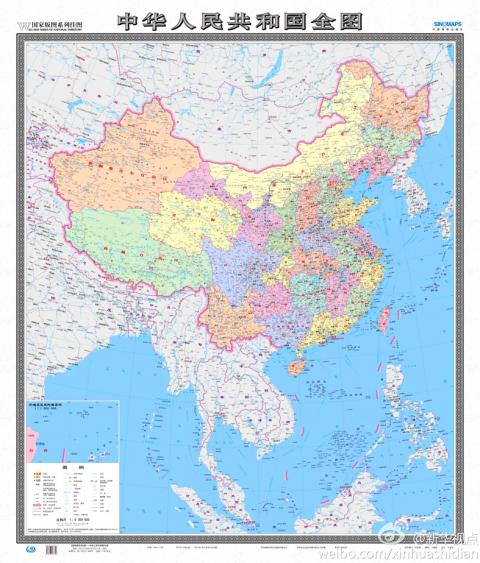
The new map of the entire
territory claimed by Beijing as the People’s Republic of China that will be
released later this month is pictured.
Photo from stcn.com
A new map to be released later this month
by China’s National Administration of Surveying, Mapping and Geoinformation
increases from 29 to 130 the number of disputed areas marked as officially part
of the People’s Republic of China (PRC), including the Diaoyutai Islands (釣魚台)
claimed by Taiwan and Japan.
Previous editions of the “Wall Map Series of National Territory,” which
presented China’s claimed territory in horizontal format, only included the
larger contested islands in the South China Sea in a separate box at the bottom
right of the map, Xinhua news agency said at the weekend. The territories
included in the box were half scale and not clearly detailed.
The new map is vertical and is to be distributed by Sinomaps Press on behalf of
the Chinese authorities starting next month. It will for the first time display
the entirety of the PRC’s claimed territory on the same scale as continental
China.
“The new map will be very significant in enhancing Chinese people’s awareness of
national territory, safeguarding China’s marine rights and interests and
manifesting China’s political diplomatic stance,” Xu Gencai (徐根才),
editor-in-chief at Sinomaps Press, told Xinhua.
In all, the map includes 130 disputed areas, including Taiwan, islets and coral
reefs in the Spratlys (Nansha Islands, 南沙群島), the Paracels (Xisha Islands,
西沙群島), the Pratas (Dongshan Islands, 東沙群島), the Macclesfield Bank (Zhongsha
Islands, 中沙群島) and the Scarborough Shoal (Huangyan Island (黃岩島), which are the
object of disputes between Taiwan, China, the Philippines, Vietnam, Brunei and
Malaysia. It also includes the Diaoyutais, in the East China Sea.
In another first, an inset shows the northern tip of Taiwan and detailed mapping
of the eight major islets comprising the Diaoyutais, known as the Senkakus by
Japan.
Tensions in the area escalated last week, with China and Japan dispatching
fighter aircraft after Chinese aircraft penetrated Japan’s Air Defense
Identification Zone near the islets on three occasions.
Lu Chang-shui (盧長水), head of the Mainland Affairs Council’s Department of
Information and Liaison, said the map was different from the one in new Chinese
passports showing Taiwan and the South China Sea as Chinese territory, as well
as pictures of Taiwanese tourist spots.
“A passport represents national sovereignty and a map is for a country’s
internal use,” Lu said. “Consequently, the council will use different approaches
to deal with the map and the passport.”
Lu added that official maps published by the government include the PRC as part
of Republic of China (ROC) territory, as dictated by the ROC Constitution.
In related developments, state broadcaster NHK reported yesterday that Japan
would deploy two additional patrol ships at its regional coast guard
headquarters responsible for territory that includes the Senkakus.
The 335-tonne Kurose and the 3,100-tonne Chikuzen, which comes equipped with a
helicopter, will be deployed in August and October respectively, it said.
Meanwhile, during a meeting in Sydney on Sunday, Japanese Minister of Foreign
Affairs Fumio Kishida and Australian Minister of Foreign Affairs Bob Carr told a
press conference that the two countries had agreed to increase bilateral
cooperation on security issues, Kyodo news agency reported yesterday.
Additionally, the Asahi Shimbun reported that Japanese Prime Minister Shinzo Abe
would embark on a trip to Southeast Asia tomorrow — his first since assuming
office last month — where he will seek to deepen cooperation with ASEAN
countries on trade, energy and security matters.
Additional reporting by Shih Hsiu-chuan and AFP
|